Geolocate

Foula topographic map

Click on the map to display elevation.

About this map

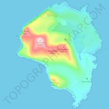
Name: Foula topographic map, elevation, terrain.

Location: Foula, Shetland, Scotland, ZE2 9PN, United Kingdom (60.10948 -2.11625 60.15809 -2.03956)

Average elevation: 50 m

Minimum elevation: -1 m

Maximum elevation: 400 m

Shetland trails, hiking, mountain biking, running and outdoor activities

Other topographic maps

Click on a map to view its topography, its elevation and its terrain.

Scot Knowe

United Kingdom > Scotland > Shetland

Average elevation: 40 m

Fitful Head

United Kingdom > Scotland > Shetland

Average elevation: 68 m

Ronas Hill

United Kingdom > Scotland > Shetland

Ronas Hill (or Rönies Hill) is a hill in Shetland, Scotland. It is classed as a Marilyn, and is the highest point in the Shetland Islands at an elevation of 450 m (1,480 ft). A Neolithic chambered cairn is located near the summit.

Average elevation: 298 m

Da Sneug

United Kingdom > Scotland > Shetland

Average elevation: 125 m

Whalsay

United Kingdom > Scotland > Shetland > Symbister

Average elevation: 12 m

Mousa

United Kingdom > Scotland > Shetland

Average elevation: 3 m

Twatt

United Kingdom > Scotland > Shetland

Average elevation: 35 m

Aywick

United Kingdom > Scotland > Shetland

Average elevation: 36 m

Ulsta

United Kingdom > Scotland > Shetland

Average elevation: 23 m

Papa Stour

United Kingdom > Scotland > Shetland

Average elevation: 9 m

Lamba

United Kingdom > Scotland > Shetland

Average elevation: 1 m

Papa Stour

United Kingdom > Scotland > Shetland

Average elevation: 9 m

Burwick

United Kingdom > Scotland > Shetland > Scalloway

Average elevation: 28 m

Valsgarth

United Kingdom > Scotland > Shetland > Saxa Vord

Average elevation: 45 m

Kirkabister

United Kingdom > Scotland > Shetland

Average elevation: 38 m

Holm of Melby

United Kingdom > Scotland > Shetland

Average elevation: 4 m

Mid Yell

United Kingdom > Scotland > Shetland

Average elevation: 48 m

Norwick

United Kingdom > Scotland > Shetland > Saxa Vord

Average elevation: 53 m

Camb

United Kingdom > Scotland > Shetland

Average elevation: 47 m

Bigga

United Kingdom > Scotland > Shetland > Ulsta

Average elevation: 3 m

North Gluss

United Kingdom > Scotland > Shetland

Average elevation: 62 m

Scalloway

United Kingdom > Scotland > Shetland

Average elevation: 43 m

Saxa Vord

United Kingdom > Scotland > Shetland

Average elevation: 50 m

Hamnafield

United Kingdom > Scotland > Shetland

Average elevation: 117 m

Bigton

United Kingdom > Scotland > Shetland

Average elevation: 66 m

Cunningsburgh

United Kingdom > Scotland > Shetland > Aithsetter

Average elevation: 61 m

Sandwick

United Kingdom > Scotland > Shetland

Average elevation: 18 m

Sumburgh

United Kingdom > Scotland > Shetland > Scatness

Average elevation: 4 m

Brae

United Kingdom > Scotland > Shetland

Average elevation: 38 m

Hamnavoe

United Kingdom > Scotland > Shetland

Average elevation: 6 m

Dale Hill

United Kingdom > Scotland > Shetland

Average elevation: 109 m

Gear up for your next adventure:

🥾Walking Shoes - Lightweight walking shoes for countryside and coastal paths
🧦Merino Wool Hiking Socks - Moisture-wicking socks to prevent blisters during long mountain walks
👕Technical Hiking Tees - Moisture-management for high-exertion climbs
📍Handheld GPS Navigators - Reliable satellite navigation for hiking and off-road exploration
🧣Neck Gaiters - Protects against wind and sun on exposed ridges and peaks

As an Amazon Associate, this site earns from qualifying purchases at no extra cost to you.