
Hugo topographic map
Click on the map to display elevation.
About this map
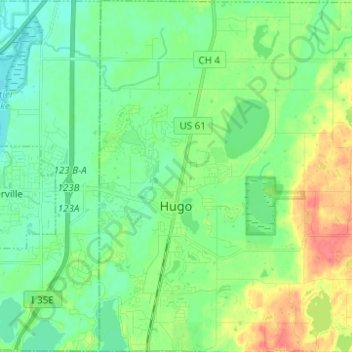
Name: Hugo topographic map, elevation, terrain.
Location: Hugo, Washington County, Minnesota, United States (45.12362 -93.02044 45.21090 -92.89694)
Average elevation: 284 m
Minimum elevation: 268 m
Maximum elevation: 320 m
Other topographic maps
Click on a map to view its topography, its elevation and its terrain.
Grey Cloud Island
United States > Minnesota > Washington County > Grey Cloud Island Township
Average elevation: 225 m
St. Croix River Boom Site Landing
United States > Minnesota > Washington County > Stillwater Township
Average elevation: 253 m
Twin Pine Mobile Home Park
United States > Minnesota > Washington County > Hugo
Average elevation: 282 m