Geolocate

Ravet topographic map

Click on the map to display elevation.

About this map

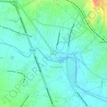
Name: Ravet topographic map, elevation, terrain.

Location: Ravet, Haveli Subdistrict, Pune District, Maharashtra, 412110, India (18.62327 73.72506 18.66327 73.76506)

Average elevation: 576 m

Minimum elevation: 559 m

Maximum elevation: 636 m

Other topographic maps

Click on a map to view its topography, its elevation and its terrain.

Mutha

India > Maharashtra > Haveli Subdistrict > Sangrun

Average elevation: 671 m

Gear up for your next adventure:

📸Action Camera Chest Mounts - Record your ascent following topographic paths hands-free
👟Heavy Duty Boot Laces - Always carry a spare for your hiking footwear
🥤Collapsible Water Bottles - Save space in your rucksack as you consume your water
🧤Waterproof Overmitts - Extreme weather protection for hikers and mountaineers
🥾Walking Shoes - Lightweight walking shoes for countryside and coastal paths

As an Amazon Associate, this site earns from qualifying purchases at no extra cost to you.