
Bhakhand topographic map
Interactive map
Click on the map to display elevation.
About this map
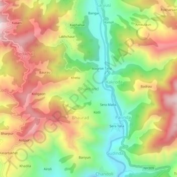
Name: Bhakhand topographic map, elevation, terrain.
Average elevation: 1,523 m
Minimum elevation: 1,162 m
Maximum elevation: 1,913 m
Other topographic maps
Click on a map to view its topography, its elevation and its terrain.
Dungri Malli
India > Uttarakhand > Thailisain
Dungri Malli, Thailisain, Pauri Garhwal District, Uttarakhand, India
Average elevation: 2,040 m
Thailisain
India > Uttarakhand > Thailisain
Thailisain, Pauri Garhwal, Uttarakhand, India
Average elevation: 1,704 m
Chopta
India > Uttarakhand > Thailisain
Chopta, Thailisain, Pauri Garhwal District, Uttarakhand, 246275, India
Average elevation: 1,921 m