Geolocate

Moulin Picoli topographic map

Interactive map

Click on the map to display elevation.

About this map

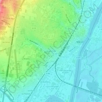
Name: Moulin Picoli topographic map, elevation, terrain.

Location: Moulin Picoli, Saint-Clément, Mâcon, Saône-et-Loire, Bourgogne-Franche-Comté, France métropolitaine, 71000, France (46.28003 4.79579 46.32003 4.83579)

Average elevation: 197 m

Minimum elevation: 166 m

Maximum elevation: 288 m

Other topographic maps

Click on a map to view its topography, its elevation and its terrain.

Les Bouttières

France > Bourgogne-Franche-Comté > Saône-et-Loire > Mâcon > Saint-Clément

Les Bouttières, Saint-Clément, Mâcon, Saône-et-Loire, Bourgogne-Franche-Comté, France métropolitaine, 71000, France

Average elevation: 187 m

Zone Industrielle Sud

France > Bourgogne-Franche-Comté > Saône-et-Loire > Mâcon > Saint-Clément

Zone Industrielle Sud, Saint-Clément, Mâcon, Saône-et-Loire, Bourgogne-Franche-Comté, France métropolitaine, 71000, France

Average elevation: 183 m