
Pleasant Bay topographic map
Interactive map
Click on the map to display elevation.
About this map
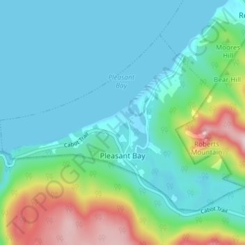
Name: Pleasant Bay topographic map, elevation, terrain.
Average elevation: 80 m
Minimum elevation: -2 m
Maximum elevation: 364 m
Other topographic maps
Click on a map to view its topography, its elevation and its terrain.
West Bay
Canada > Nova Scotia > Municipality of the County of Inverness
West Bay, Municipality of the County of Inverness, Inverness County, Nova Scotia, Canada
Average elevation: 109 m
Big Brook
Canada > Nova Scotia > Municipality of the County of Inverness
Big Brook, Municipality of the County of Inverness, Inverness County, Nova Scotia, Canada
Average elevation: 127 m
Mull River
Canada > Nova Scotia > Municipality of the County of Inverness > Mabou
Mull River, Mabou, Municipality of the County of Inverness, Inverness County, Nova Scotia, Canada
Average elevation: 83 m
Dunmore
Canada > Nova Scotia > Municipality of the County of Inverness
Dunmore, Municipality of the County of Inverness, Inverness County, Nova Scotia, Canada
Average elevation: 28 m
Point Cross
Canada > Nova Scotia > Municipality of the County of Inverness > Point Cross
Point Cross, Municipality of the County of Inverness, Inverness County, Nova Scotia, Canada
Average elevation: 97 m
Mabou
Canada > Nova Scotia > Municipality of the County of Inverness > Mabou
Mabou, Municipality of the County of Inverness, Inverness County, Nova Scotia, Canada
Average elevation: 81 m
Gillis Cove
Canada > Nova Scotia > Municipality of the County of Inverness
Gillis Cove, Municipality of the County of Inverness, Inverness County, Nova Scotia, Canada
Average elevation: 13 m
Kewstoke
Canada > Nova Scotia > Municipality of the County of Inverness
Kewstoke, Municipality of the County of Inverness, Inverness County, Nova Scotia, Canada
Average elevation: 161 m
Whycocomagh
Canada > Nova Scotia > Municipality of the County of Inverness
Whycocomagh, Municipality of the County of Inverness, Inverness County, Nova Scotia, B0E 3M0, Canada
Average elevation: 135 m