
Slaithwaite topographic map
Click on the map to display elevation.
Slaithwaite
In the 1848 edition of 'A Topographical Dictionary of England', Samuel Lewis (the editor) wrote:- "the lands are in meadow and pasture, with a small portion of arable; the scenery is bold and romantic. In the quarries of the district are found vegetable fossils, especially firs and other mountain trees. The village is beautifully seated in the valley of the river Colne; the inhabitants are chiefly employed in the woollen manufacture, in the spinning of cotton and silk, and in silk-weaving"
About this map
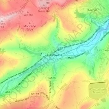
Name: Slaithwaite topographic map, elevation, terrain.
Average elevation: 241 m
Minimum elevation: 107 m
Maximum elevation: 391 m
England trails, hiking, mountain biking, running and outdoor activities
Other topographic maps
Click on a map to view its topography, its elevation and its terrain.