
Make a donation
Gear up for your next adventure:
As an Amazon Associate, this site earns from qualifying purchases at no extra cost to you.
Hartsop Above How topographic map
Click on the map to display elevation.
Make a donation
Gear up for your next adventure:
As an Amazon Associate, this site earns from qualifying purchases at no extra cost to you.
About this map
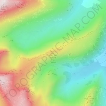
Name: Hartsop Above How topographic map, elevation, terrain.
Average elevation: 429 m
Minimum elevation: 167 m
Maximum elevation: 836 m
Westmorland and Furness trails, hiking, mountain biking, running and outdoor activities
Make a donation
Gear up for your next adventure:
As an Amazon Associate, this site earns from qualifying purchases at no extra cost to you.
Other topographic maps
Click on a map to view its topography, its elevation and its terrain.
Brown Cove Tarn
United Kingdom > England > Westmorland and Furness > Patterdale
Average elevation: 699 m
Brothers Water
United Kingdom > England > Westmorland and Furness > Patterdale > Hartsop
Average elevation: 298 m
Make a donation
Gear up for your next adventure:
As an Amazon Associate, this site earns from qualifying purchases at no extra cost to you.