Make a donation
Gear up for your next adventure:
As an Amazon Associate, this site earns from qualifying purchases at no extra cost to you.
Orange topographic map
Click on the map to display elevation.
Make a donation
Gear up for your next adventure:
As an Amazon Associate, this site earns from qualifying purchases at no extra cost to you.
About this map
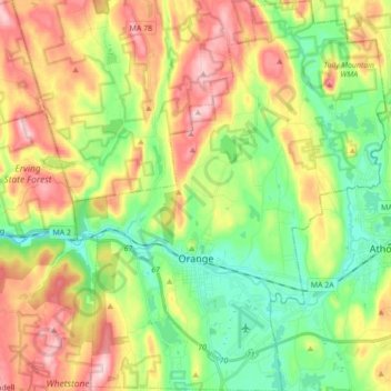
Name: Orange topographic map, elevation, terrain.
Location: Orange, Franklin County, Massachusetts, 01364, United States (42.54723 -72.36477 42.67542 -72.22493)
Average elevation: 233 m
Minimum elevation: 139 m
Maximum elevation: 381 m
Make a donation
Gear up for your next adventure:
As an Amazon Associate, this site earns from qualifying purchases at no extra cost to you.
Other topographic maps
Click on a map to view its topography, its elevation and its terrain.
North Sunderland
United States > Massachusetts > Franklin County > Sunderland
Average elevation: 100 m
Make a donation
Gear up for your next adventure:
As an Amazon Associate, this site earns from qualifying purchases at no extra cost to you.
Make a donation
Gear up for your next adventure:
As an Amazon Associate, this site earns from qualifying purchases at no extra cost to you.
