
La Laiterie topographic map
Interactive map
Click on the map to display elevation.
About this map
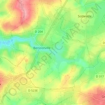
Name: La Laiterie topographic map, elevation, terrain.
Average elevation: 78 m
Minimum elevation: 33 m
Maximum elevation: 131 m
Other topographic maps
Click on a map to view its topography, its elevation and its terrain.
Hameau Terrier
France > Normandie > Manche > Benoîstville
Hameau Terrier, Benoîstville, Cherbourg, Manche, Normandie, France métropolitaine, 50340, France
Average elevation: 77 m
La Croix Georges
France > Normandie > Manche > Benoîstville
La Croix Georges, Benoîstville, Cherbourg, Manche, Normandie, France métropolitaine, 50340, France
Average elevation: 81 m