
Bruniquel topographic map
Interactive map
Click on the map to display elevation.
Bruniquel
Bruniquel liegt auf einer Anhöhe über dem linken Ufer des Aveyron, an der Einmündung seines Nebenflusses Vère. Die Stadt Montauban liegt etwa 28 Kilometer westlich; der Weinort Gaillac etwa 35 Kilometer südöstlich. Die ebenfalls zu den „Schönsten Dörfern Frankreichs“ gehörenden Orte Puycelsi und Castelnau-de-Montmiral befinden sich zwölf bzw. 23 Kilometer südöstlich.
About this map
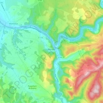
Name: Bruniquel topographic map, elevation, terrain.
Average elevation: 215 m
Minimum elevation: 93 m
Maximum elevation: 470 m