
Make a donation
Gear up for your next adventure:
As an Amazon Associate, this site earns from qualifying purchases at no extra cost to you.
Sparta topographic map
Click on the map to display elevation.
Make a donation
Gear up for your next adventure:
As an Amazon Associate, this site earns from qualifying purchases at no extra cost to you.
Sparta
In 1907, the location of the sanctuary of Athena "of the Brazen House" (Χαλκίοικος, Chalkioikos) was determined to be on the acropolis immediately above the theatre. Though the actual temple is almost completely destroyed, the site has produced the longest extant archaic inscription in Laconia, numerous bronze nails and plates, and a considerable number of votive offerings. The city-wall, built in successive stages from the 4th to the 2nd century, was traced for a great part of its circuit, which measured 48 stades or nearly 10 km (6 miles) (Polyb. 1X. 21). The late Roman wall enclosing the acropolis, part of which probably dates from the years following the Gothic raid of CE 262, was also investigated. Besides the actual buildings discovered, a number of points were situated and mapped in a general study of Spartan topography, based upon the description of Pausanias.
Make a donation
Gear up for your next adventure:
As an Amazon Associate, this site earns from qualifying purchases at no extra cost to you.
About this map
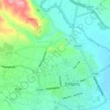
Name: Sparta topographic map, elevation, terrain.
Average elevation: 214 m
Minimum elevation: 175 m
Maximum elevation: 325 m
Make a donation
Gear up for your next adventure:
As an Amazon Associate, this site earns from qualifying purchases at no extra cost to you.