
Williston topographic map
Interactive map
Click on the map to display elevation.
About this map
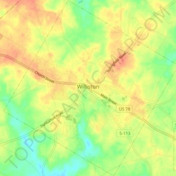
Name: Williston topographic map, elevation, terrain.
Average elevation: 101 m
Minimum elevation: 77 m
Maximum elevation: 121 m
Other topographic maps
Click on a map to view its topography, its elevation and its terrain.
Blackville
United States > South Carolina > Barnwell County
Blackville, Barnwell County, South Carolina, 29817, United States
Average elevation: 85 m
Barnwell
United States > South Carolina > Barnwell County > Barnwell
Barnwell, Barnwell County, South Carolina, 29812, United States
Average elevation: 65 m
Hilda
United States > South Carolina > Barnwell County > Hilda
Hilda, Barnwell County, South Carolina, 29813, United States
Average elevation: 78 m