
Castedo topographic map
Interactive map
Click on the map to display elevation.
About this map
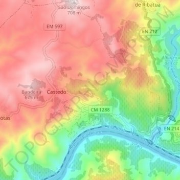
Name: Castedo topographic map, elevation, terrain.
Average elevation: 392 m
Minimum elevation: 73 m
Maximum elevation: 708 m
Other topographic maps
Click on a map to view its topography, its elevation and its terrain.
Cotas
Portugal > Norte > Castedo e Cotas
Cotas, Castedo e Cotas, Alijó, Vila Real, Douro, Norte, Portugal
Average elevation: 439 m