
Make a donation
Gear up for your next adventure:
As an Amazon Associate, this site earns from qualifying purchases at no extra cost to you.
Ripley topographic map
Click on the map to display elevation.
Make a donation
Gear up for your next adventure:
As an Amazon Associate, this site earns from qualifying purchases at no extra cost to you.
About this map
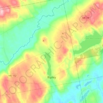
Name: Ripley topographic map, elevation, terrain.
Location: Ripley, Somerset County, Maine, United States (44.96824 -69.48234 45.06715 -69.33095)
Average elevation: 147 m
Minimum elevation: 80 m
Maximum elevation: 252 m
Make a donation
Gear up for your next adventure:
As an Amazon Associate, this site earns from qualifying purchases at no extra cost to you.
Other topographic maps
Click on a map to view its topography, its elevation and its terrain.
No Name Pond
United States > Maine > Somerset County > Bald Mountain Township T4 R3
Average elevation: 686 m
Make a donation
Gear up for your next adventure:
As an Amazon Associate, this site earns from qualifying purchases at no extra cost to you.