
Darhan topographic map
Interactive map
Click on the map to display elevation.
About this map
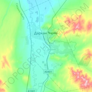
Name: Darhan topographic map, elevation, terrain.
Location: Darhan, Darkhan-Uul, Mongolia (49.38809 105.87491 49.54931 106.05117)
Average elevation: 766 m
Minimum elevation: 672 m
Maximum elevation: 1,076 m
With an elevation of 665 metres or 2,182 feet, Darkhan is the capital of the Darkhan-Uul Province. It is a city with notable Soviet influence, it can be seen from huge square buildings and pretty heavy Cyrillic usage.being surrounded by mountains and hills, and too having some tourist attractions like statues largely being Buddhist attractions. Some parts of the city have wooden houses.