
Muhanga topographic map
Interactive map
Click on the map to display elevation.
About this map
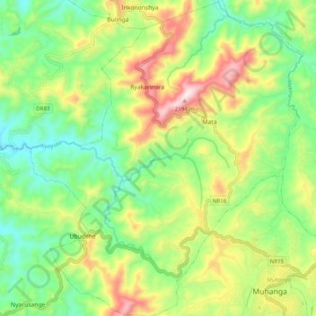
Name: Muhanga topographic map, elevation, terrain.
Location: Muhanga, Muhanga District, Southern Province, Rwanda (-2.09235 29.67808 -1.99392 29.76378)
Average elevation: 1,803 m
Minimum elevation: 1,566 m
Maximum elevation: 2,190 m
Other topographic maps
Click on a map to view its topography, its elevation and its terrain.
Nsanga
Rwanda > Southern Province > Muhanga District > Rugendabari
Nsanga, Rugendabari, Muhanga District, Southern Province, Rwanda
Average elevation: 1,711 m
Kiyumba
Rwanda > Southern Province > Muhanga District
Kiyumba, Muhanga District, Southern Province, Rwanda
Average elevation: 1,619 m