
Khujand topographic map
Interactive map
Click on the map to display elevation.
About this map
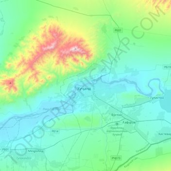
Name: Khujand topographic map, elevation, terrain.
Location: Khujand, Ghafurov District, Sughd Region, 735700, Tajikistan (40.12931 69.46322 40.44931 69.78322)
Average elevation: 548 m
Minimum elevation: 316 m
Maximum elevation: 1,613 m
Other topographic maps
Click on a map to view its topography, its elevation and its terrain.
Khujand
Tajikistan > Sughd Region > Ghafurov District > Khujand
Khujand, Ghafurov District, Sughd Region, 735700, Tajikistan
Average elevation: 510 m