
Thank you for supporting this site ❤️
Make a donation
Make a donation
Gear up for your next adventure:
As an Amazon Associate, this site earns from qualifying purchases at no extra cost to you.
Chansin topographic map
Click on the map to display elevation.
Thank you for supporting this site ❤️
Make a donation
Make a donation
Gear up for your next adventure:
As an Amazon Associate, this site earns from qualifying purchases at no extra cost to you.
Chansin
Chansin se situe dans la vallée du Bocq, à une altitude de 180 m. Près du hameau se situe une carrière.
Thank you for supporting this site ❤️
Make a donation
Make a donation
Gear up for your next adventure:
As an Amazon Associate, this site earns from qualifying purchases at no extra cost to you.
About this map
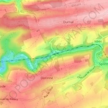
Name: Chansin topographic map, elevation, terrain.
Location: Chansin, Dorinne, Yvoir, Dinant, Namur, Wallonie, 5532, Belgique (50.30619 4.95750 50.34619 4.99750)
Average elevation: 244 m
Minimum elevation: 140 m
Maximum elevation: 303 m
Thank you for supporting this site ❤️
Make a donation
Make a donation
Gear up for your next adventure:
As an Amazon Associate, this site earns from qualifying purchases at no extra cost to you.