
Wasagaming topographic map
Click on the map to display elevation.
Wasagaming
Wasagaming has a subarctic climate (Dfc) due to its northerly location and high elevation. Winters are extremely cold and relatively dry with little chance of a mid-winter thaw. The average annual temperature is 0.7 °C (33.3 °F). Annual precipitation is 488 mm (19.2 in).
About this map
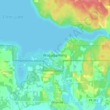
Name: Wasagaming topographic map, elevation, terrain.
Average elevation: 630 m
Minimum elevation: 615 m
Maximum elevation: 683 m
Other topographic maps
Click on a map to view its topography, its elevation and its terrain.
Riding Mountain National Park
Canada > Manitoba > Unorganized Division No. 17 > Wasagaming
Riding Mountain Biosphere Reserve covers 15,000 square kilometers of land in South-western Manitoba, with the core area, Riding Mountain National Park (RMNP), covering nearly 3,000 square kilometers. It is some 300 km northwest of Winnipeg, Manitoba. The local climate is cool and moist due to a higher…
Average elevation: 488 m