
Nazareth topographic map
Interactive map
Click on the map to display elevation.
About this map
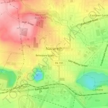
Name: Nazareth topographic map, elevation, terrain.
Location: Nazareth, Northampton County, Pennsylvania, United States (40.73036 -75.33071 40.75154 -75.29733)
Average elevation: 149 m
Minimum elevation: 56 m
Maximum elevation: 224 m
Nazareth's climate is similar to the rest of the Lehigh Valley, with four distinct seasons, humid summers, cold winters, and very short and mild springs and falls. This climate is hot-summer humid continental (Dfa) and average monthly temperatures range from 28.1 °F (−2.2 °C) in January to 73.4 °F (23.0 °C) in July. The hardiness zone is 6b. Nazareth's topography can best be described as hilly, as the town itself sits atop a local outcropping underground of one of the richest veins of limestone in the U.S. Much of the farmland surrounding Nazareth is being converted into close sitting lots of suburban housing, for predominantly commuter households.