Geolocate

Kas topographic map

Click on the map to display elevation.

About this map

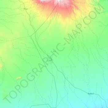
Name: Kas topographic map, elevation, terrain.

Location: Kas, South Darfur State, Sudan (12.17641 24.14811 12.91561 24.46780)

Average elevation: 1,048 m

Minimum elevation: 757 m

Maximum elevation: 2,422 m

Other topographic maps

Click on a map to view its topography, its elevation and its terrain.

Al Buddi

Sudan > South Darfur State > Nyala

Average elevation: 482 m

Towe

Sudan > South Darfur State > Nyala

Average elevation: 1,542 m

Tu

Sudan > South Darfur State > Kas > Madu

Average elevation: 1,953 m

Bulbul

Sudan > South Darfur State > Nyala

Average elevation: 806 m

Gear up for your next adventure:

🔋Power Banks - Portable chargers for long outdoor trips
🧺Microfibre Travel Towels - Fast-drying and compact towels for wild swimming and camping
🗺️Ordnance Survey Maps - Essential paper maps for hiking across the UK national parks
🔥Emergency Fire Starters - Reliable ignition tools for survival situations in damp conditions
🐕Dog Hiking Gear - Equipment for hiking safely with dogs

As an Amazon Associate, this site earns from qualifying purchases at no extra cost to you.