
Clover topographic map
Interactive map
Click on the map to display elevation.
About this map
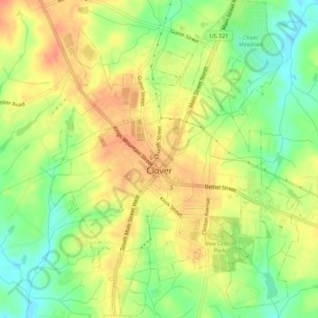
Name: Clover topographic map, elevation, terrain.
Location: Clover, York County, South Carolina, United States (35.09346 -81.24254 35.13183 -81.20580)
Average elevation: 234 m
Minimum elevation: 208 m
Maximum elevation: 254 m
Other topographic maps
Click on a map to view its topography, its elevation and its terrain.
Rock Hill
United States > South Carolina > York County > Rock Hill > Rock Hill
Average elevation: 185 m
Boyd Hill
United States > South Carolina > York County > Rock Hill > Boyd Hill
Average elevation: 192 m