
Make a donation
Gear up for your next adventure:
As an Amazon Associate, this site earns from qualifying purchases at no extra cost to you.
Bellentre topographic map
Click on the map to display elevation.
Make a donation
Gear up for your next adventure:
As an Amazon Associate, this site earns from qualifying purchases at no extra cost to you.
Bellentre
Sous l'impulsion de son maire Auguste Mudry, la station village de Montchavin, à 1 250 m d'altitude, voit le jour en 1972.
Make a donation
Gear up for your next adventure:
As an Amazon Associate, this site earns from qualifying purchases at no extra cost to you.
About this map
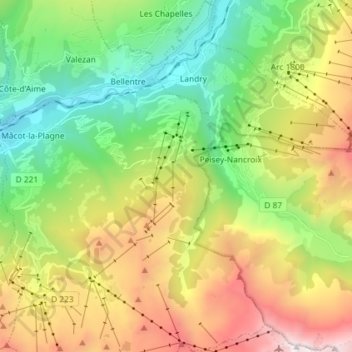
Name: Bellentre topographic map, elevation, terrain.
Average elevation: 1,704 m
Minimum elevation: 661 m
Maximum elevation: 3,404 m
Make a donation
Gear up for your next adventure:
As an Amazon Associate, this site earns from qualifying purchases at no extra cost to you.
Other topographic maps
Click on a map to view its topography, its elevation and its terrain.
Make a donation
Gear up for your next adventure:
As an Amazon Associate, this site earns from qualifying purchases at no extra cost to you.
Mâcot-la-Plagne
France > Auvergne-Rhône-Alpes > Savoie > La Plagne-Tarentaise
Average elevation: 1,015 m
Make a donation
Gear up for your next adventure:
As an Amazon Associate, this site earns from qualifying purchases at no extra cost to you.
Make a donation
Gear up for your next adventure:
As an Amazon Associate, this site earns from qualifying purchases at no extra cost to you.
Plan d'eau Base de loisirs
France > Auvergne-Rhône-Alpes > Savoie > La Plagne-Tarentaise > Le Villard de Sangot
Average elevation: 937 m
Plagne Villages
France > Auvergne-Rhône-Alpes > Savoie > La Plagne-Tarentaise
Average elevation: 2,104 m
Make a donation
Gear up for your next adventure:
As an Amazon Associate, this site earns from qualifying purchases at no extra cost to you.
Plagne Centre
France > Auvergne-Rhône-Alpes > Savoie > La Plagne-Tarentaise
Average elevation: 2,078 m
Les Chacruets
France > Auvergne-Rhône-Alpes > Savoie > La Plagne-Tarentaise
Average elevation: 1,109 m
Plagne Soleil
France > Auvergne-Rhône-Alpes > Savoie > La Plagne-Tarentaise
Average elevation: 2,094 m
Make a donation
Gear up for your next adventure:
As an Amazon Associate, this site earns from qualifying purchases at no extra cost to you.
Make a donation
Gear up for your next adventure:
As an Amazon Associate, this site earns from qualifying purchases at no extra cost to you.
Le Villard de Sangot
France > Auvergne-Rhône-Alpes > Savoie > La Plagne-Tarentaise
Average elevation: 1,084 m
Plagne Centre
France > Auvergne-Rhône-Alpes > Savoie > La Plagne-Tarentaise
Average elevation: 2,078 m