
Mota Lava topographic map
Interactive map
Click on the map to display elevation.
About this map
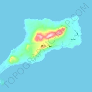
Name: Mota Lava topographic map, elevation, terrain.
Location: Mota Lava, Torba, Vanuatu (-13.71146 167.61757 -13.64664 167.71673)
Average elevation: 26 m
Minimum elevation: 0 m
Maximum elevation: 409 m
Other topographic maps
Click on a map to view its topography, its elevation and its terrain.
Linua
Linua has a length of 2.8 km and diameter of 1 km. The estimated terrain elevation above sea level is 23 meters. Linua lies about 60 miles (100 km) north of Espiritu Santo Island between islands of Tegua and Lo. The island is surrounded by coral reefs. There is an airstrip on the island opened in 1983 that…
Average elevation: 5 m