
Make a donation
Gear up for your next adventure:
As an Amazon Associate, this site earns from qualifying purchases at no extra cost to you.
Andaman Islands topographic map
Click on the map to display elevation.
Make a donation
Gear up for your next adventure:
As an Amazon Associate, this site earns from qualifying purchases at no extra cost to you.
About this map
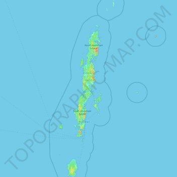
Name: Andaman Islands topographic map, elevation, terrain.
Location: Andaman Islands, Andaman and Nicobar Islands, India (10.51113 92.20421 14.19306 93.38267)
Average elevation: 2 m
Minimum elevation: -1 m
Maximum elevation: 662 m
Make a donation
Gear up for your next adventure:
As an Amazon Associate, this site earns from qualifying purchases at no extra cost to you.
Other topographic maps
Click on a map to view its topography, its elevation and its terrain.
Barren Island
India > Andaman and Nicobar Islands
This volcanic island stands in the midst of a volcanic belt on the edge of the Indian and Burmese tectonic plates. Narcondam Island is a dormant volcano in the area, apart from volcanic seamounts like Alcock and Sewell. All the historical and recent eruptions (1789 and after) are confined within and around an…
Average elevation: 108 m
Make a donation
Gear up for your next adventure:
As an Amazon Associate, this site earns from qualifying purchases at no extra cost to you.
Tarasa Dwip Island
India > Andaman and Nicobar Islands > Nancowry
Teressa lies west of the neighboring island of Camorta and northwest of Katchal. The smaller island known as Chowra is to the north and Bompoka lies to the east. The northern portion of the island has elevations reaching 87 meters. The island has a surface area of 101.26 km2.
Average elevation: 12 m
Make a donation
Gear up for your next adventure:
As an Amazon Associate, this site earns from qualifying purchases at no extra cost to you.