
Make a donation
Gear up for your next adventure:
As an Amazon Associate, this site earns from qualifying purchases at no extra cost to you.
Bering Glacier topographic map
Click on the map to display elevation.
Make a donation
Gear up for your next adventure:
As an Amazon Associate, this site earns from qualifying purchases at no extra cost to you.
About this map
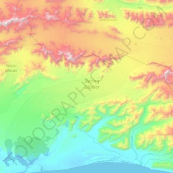
Name: Bering Glacier topographic map, elevation, terrain.
Location: Bering Glacier, Yakutat, Alaska, United States (60.17757 -143.61521 60.64592 -142.19138)
Average elevation: 865 m
Minimum elevation: -4 m
Maximum elevation: 3,225 m
Make a donation
Gear up for your next adventure:
As an Amazon Associate, this site earns from qualifying purchases at no extra cost to you.
Other topographic maps
Click on a map to view its topography, its elevation and its terrain.
Hubbard Glacier
United States > Alaska > Yakutat
The longest source for Hubbard Glacier originates 122 kilometres (76 mi) from its snout and is located at about 61°00′N 140°09′W / 61.000°N 140.150°W / 61.000; -140.150, approximately 8 kilometres (5 mi) west of Mount Walsh with an elevation around 3,400 metres (11,200 ft). A shorter tributary…
Average elevation: 1,892 m
Mount Steller
United States > Alaska > Yakutat
Due to its isolated location, poor weather, and comparatively low absolute elevation by Alaskan standards, Mount Steller was not climbed until recently. The first ascent was in 1992.
Average elevation: 2,578 m
Mount Fairweather
United States > Alaska > Yakutat
Mount Fairweather (or Tsalxaan in the Tlingit language) is a mountain located 20 km (12 mi) east of the Pacific Ocean on the Canada–United States border. With an elevation of 4,653 metres (15,266 ft), it is the tallest mountain in British Columbia and the seventh-tallest mountain in both Alaska and the…
Average elevation: 3,845 m
Make a donation
Gear up for your next adventure:
As an Amazon Associate, this site earns from qualifying purchases at no extra cost to you.
Make a donation
Gear up for your next adventure:
As an Amazon Associate, this site earns from qualifying purchases at no extra cost to you.
Hubbard Glacier
United States > Alaska > Yakutat
The longest source for Hubbard Glacier originates 122 kilometres (76 mi) from its snout and is located at about 61°00′N 140°09′W / 61.000°N 140.150°W / 61.000; -140.150, approximately 8 kilometres (5 mi) west of Mount Walsh with an elevation around 3,400 metres (11,200 ft). A shorter tributary…
Average elevation: 1,892 m
Mount Fairweather
United States > Alaska > Yakutat
Mount Fairweather (or Tsalxaan in the Tlingit language) is a mountain located 20 km (12 mi) east of the Pacific Ocean on the Canada–United States border. With an elevation of 4,653 metres (15,266 ft), it is the tallest mountain in British Columbia and the seventh-tallest mountain in both Alaska and the…
Average elevation: 3,845 m
Make a donation
Gear up for your next adventure:
As an Amazon Associate, this site earns from qualifying purchases at no extra cost to you.