
나주시 topographic map
Interactive map
Click on the map to display elevation.
About this map
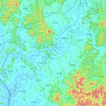
Name: 나주시 topographic map, elevation, terrain.
Location: 나주시, Jeolla do Sul, Coreia do Sul (34.86423 126.51293 35.11472 126.89878)
Average elevation: 70 m
Minimum elevation: -1 m
Maximum elevation: 526 m
Other topographic maps
Click on a map to view its topography, its elevation and its terrain.
391 봉
Coreia do Sul > Jeolla do Sul > 고달면
391 봉, 고달면, 곡성군, Jeolla do Sul, Coreia do Sul
Average elevation: 279 m