Geolocate

Middlecroft topographic map

Click on the map to display elevation.

About this map

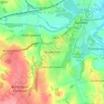
Name: Middlecroft topographic map, elevation, terrain.

Location: Middlecroft, Chesterfield, Derbyshire, England, S43 3NS, United Kingdom (53.23696 -1.38820 53.27696 -1.34820)

Average elevation: 85 m

Minimum elevation: 46 m

Maximum elevation: 143 m

Derbyshire trails, hiking, mountain biking, running and outdoor activities

Other topographic maps

Click on a map to view its topography, its elevation and its terrain.

Barlow Brook

United Kingdom > England > Derbyshire > Chesterfield > Barlow

Average elevation: 113 m

Gear up for your next adventure:

📍Handheld GPS Navigators - Reliable satellite navigation for hiking and off-road exploration
📸Action Camera Chest Mounts - Record your ascent following topographic paths hands-free
🧢Thermal Beanie Hats - Prevent heat loss from the head in windy summit conditions
🛌Sleeping Bags - Warm and packable sleeping bags for outdoor nights
🐕Hiking Dog Harnesses - Rugged harnesses for taking your companion on mountain trails

As an Amazon Associate, this site earns from qualifying purchases at no extra cost to you.