Geolocate

Bylahalli topographic map

Click on the map to display elevation.

About this map
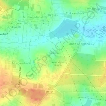
Name: Bylahalli topographic map, elevation, terrain.

Location: Bylahalli, Yelahanka taluku, Bengaluru Urban, Karnataka, 560300, India (13.14905 77.66082 13.18905 77.70082)

Average elevation: 898 m

Minimum elevation: 880 m

Maximum elevation: 921 m

Other topographic maps

Click on a map to view its topography, its elevation and its terrain.
Yelahanka Zone

India > Karnataka > Yelahanka taluku > Bellahalli

Average elevation: 910 m

Arakere

India > Karnataka > Yelahanka taluku

Average elevation: 881 m

Vidyaranyapura

India > Karnataka > Yelahanka taluku > Bengaluru

Average elevation: 920 m

Bilijaji

India > Karnataka > Yelahanka taluku

Average elevation: 865 m

Yelahanka Lake

India > Karnataka > Yelahanka taluku > Nagenahalli

Average elevation: 904 m

Amruthalli Lake

India > Karnataka > Yelahanka taluku > Bengaluru

Average elevation: 906 m

Kodigehalli

India > Karnataka > Yelahanka taluku > Bengaluru

Average elevation: 906 m

Soladevanahalli

India > Karnataka > Yelahanka taluku

Average elevation: 864 m

Sonnenahalli

India > Karnataka > Yelahanka taluku

Average elevation: 888 m

Allalasandra Lake

India > Karnataka > Yelahanka taluku

Average elevation: 915 m

Gear up for your next adventure:

📱Phone Mounts for Hiking - Secure mounts to carry your phone on trails
🍱Food Containers - Reusable containers for outdoor meals
🔋Solar Power Banks - Keep your GPS and phone charged during multi-day expeditions
📱Rugged Phone Cases - Heavy-duty protection for smartphones used as secondary GPS tools
🧥Breathable Waterproof Jackets - Essential rain protection for the unpredictable British climate

As an Amazon Associate, this site earns from qualifying purchases at no extra cost to you.