Geolocate

Banaran topographic map

Click on the map to display elevation.

About this map

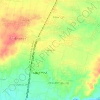
Name: Banaran topographic map, elevation, terrain.

Location: Banaran, Sragen, Central Java, Java, 57274, Indonesia (-7.45656 110.79430 -7.41656 110.83430)

Average elevation: 142 m

Minimum elevation: 108 m

Maximum elevation: 171 m

Gear up for your next adventure:

🥾Men's Waterproof Hiking Boots - Durable footwear with deep lugs for muddy and rocky UK terrains
🥄Titanium Camping Sporks - The ultimate lightweight utensil for trail meals
🔋Power Banks - Portable chargers for long outdoor trips
👖Packable Overtrousers - Quick-deploy rain protection for legs in sudden storms
🧢Thermal Beanie Hats - Prevent heat loss from the head in windy summit conditions

As an Amazon Associate, this site earns from qualifying purchases at no extra cost to you.