Geolocate

Alvingham topographic map

Click on the map to display elevation.

About this map

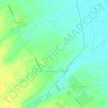
Name: Alvingham topographic map, elevation, terrain.

Location: Alvingham, East Lindsey, Lincolnshire, Greater Lincolnshire, England, United Kingdom (53.38898 0.01750 53.42445 0.07288)

Average elevation: 9 m

Minimum elevation: 0 m

Maximum elevation: 22 m

Lincolnshire trails, hiking, mountain biking, running and outdoor activities

Other topographic maps

Click on a map to view its topography, its elevation and its terrain.

Gear up for your next adventure:

🧣Fleece Neck Warmers - Extra insulation for winter topographic surveys
🧺Ultralight Dry Bags - Organize and waterproof your gear inside your rucksack
🥤Hiking Water Bottles - Reusable bottles for hydration on the trail
🗺️Scratch-off Peak Maps - Track your progress climbing Munros or Wainwrights
📐Altimeters & Barometers - Tools for measuring altitude and air pressure

As an Amazon Associate, this site earns from qualifying purchases at no extra cost to you.