Geolocate

Barkham topographic map

Click on the map to display elevation.

About this map

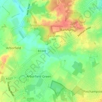
Name: Barkham topographic map, elevation, terrain.

Location: Barkham, Borough of Wokingham, England, United Kingdom (51.37608 -0.90258 51.41423 -0.86078)

Average elevation: 61 m

Minimum elevation: 40 m

Maximum elevation: 88 m

Borough of Wokingham trails, hiking, mountain biking, running and outdoor activities

Gear up for your next adventure:

🥾Hiking Boot Waterproofing Wax - Maintain the lifespan of your leather trekking boots
🎒Hiking Daypacks - Compact backpacks ideal for short hikes and excursions
🧺Mesh Stuff Sacks - Breathable storage for wet gear or camp organization
🎿Telescopic Trekking Poles - Reduces knee strain on steep topographic descents
🔋Solar Power Banks - Keep your GPS and phone charged during multi-day expeditions

As an Amazon Associate, this site earns from qualifying purchases at no extra cost to you.