
Make a donation
Gear up for your next adventure:
As an Amazon Associate, this site earns from qualifying purchases at no extra cost to you.
Zanesville topographic map
Click on the map to display elevation.
Make a donation
Gear up for your next adventure:
As an Amazon Associate, this site earns from qualifying purchases at no extra cost to you.
About this map
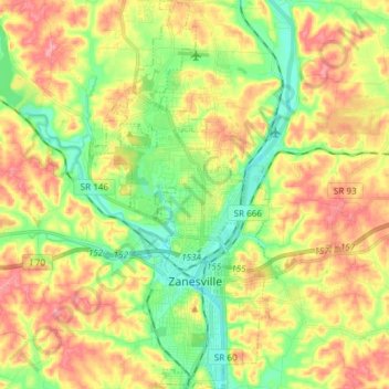
Name: Zanesville topographic map, elevation, terrain.
Location: Zanesville, Muskingum County, Ohio, 43701, United States (39.90868 -82.05405 40.02314 -81.97766)
Average elevation: 254 m
Minimum elevation: 205 m
Maximum elevation: 311 m
Make a donation
Gear up for your next adventure:
As an Amazon Associate, this site earns from qualifying purchases at no extra cost to you.
Other topographic maps
Click on a map to view its topography, its elevation and its terrain.
Make a donation
Gear up for your next adventure:
As an Amazon Associate, this site earns from qualifying purchases at no extra cost to you.
Make a donation
Gear up for your next adventure:
As an Amazon Associate, this site earns from qualifying purchases at no extra cost to you.
Hopewell
United States > Ohio > Muskingum County
The community is situated on U.S. Route 40, about a half mile north of Interstate 70, and about nine miles west of Zanesville at 39°57'21" north latitude, 82°10'15" west longitude. The ZIP code is 43746; the FIPS place code is 36358; and the elevation 1100 feet above sea level.
Average elevation: 305 m
Make a donation
Gear up for your next adventure:
As an Amazon Associate, this site earns from qualifying purchases at no extra cost to you.