
Thank you for supporting this site ❤️
Make a donation
Make a donation
Gear up for your next adventure:
As an Amazon Associate, this site earns from qualifying purchases at no extra cost to you.
Coderuto topographic map
Click on the map to display elevation.
Thank you for supporting this site ❤️
Make a donation
Make a donation
Gear up for your next adventure:
As an Amazon Associate, this site earns from qualifying purchases at no extra cost to you.
About this map
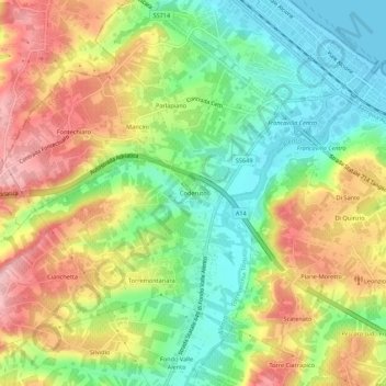
Name: Coderuto topographic map, elevation, terrain.
Location: Coderuto, Torrevecchia Teatina, Chieti, Abruzzo, 66023, Italy (42.39441 14.23701 42.43441 14.27701)
Average elevation: 77 m
Minimum elevation: -4 m
Maximum elevation: 171 m
Thank you for supporting this site ❤️
Make a donation
Make a donation
Gear up for your next adventure:
As an Amazon Associate, this site earns from qualifying purchases at no extra cost to you.