
Salen topographic map
Interactive map
Click on the map to display elevation.
About this map
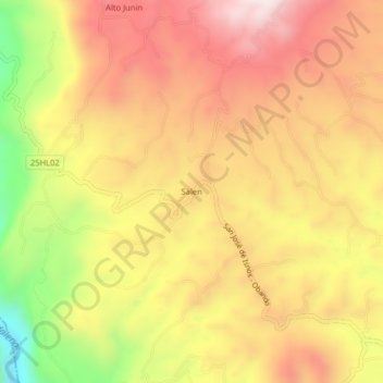
Name: Salen topographic map, elevation, terrain.
Location: Salen, Isnos, Sur, Huila, RAP (Especial) Central, Colombia (1.92170 -76.28026 1.96170 -76.24026)
Average elevation: 1,811 m
Minimum elevation: 1,392 m
Maximum elevation: 2,104 m
Other topographic maps
Click on a map to view its topography, its elevation and its terrain.
Isnos Huila
Isnos Huila, Isnos, Sur, Huila, RAP (Especial) Central, Colombia
Average elevation: 1,782 m
La Muralla
La Muralla, Isnos, Sur, Huila, RAP (Especial) Central, Colombia
Average elevation: 1,714 m
El Mortiño
El Mortiño, Isnos, Sur, Huila, RAP (Especial) Central, 418060, Colombia
Average elevation: 1,591 m
Parque Nacional Natural Puracé
Parque Nacional Natural Puracé, Isnos, Sur, Huila, RAP (Especial) Central, Colombia
Average elevation: 2,708 m
Paloquemao
Paloquemao, Isnos, Sur, Huila, RAP (Especial) Central, Colombia
Average elevation: 2,152 m