
Town of Danby topographic map
Interactive map
Click on the map to display elevation.
Town of Danby
Elevations range from approximately 450 feet above sea level where Cayuga Inlet crosses the northern town line, to about 1230 feet at Town Hall in Danby Hamlet, to just over 1800 feet at Dawes Hill in the southwestern part of the town and Roundtop in the southeastern part of the town. The dramatic hill and valley lands of Danby have sometimes been referred to as the 'Danby Highlands'.
About this map
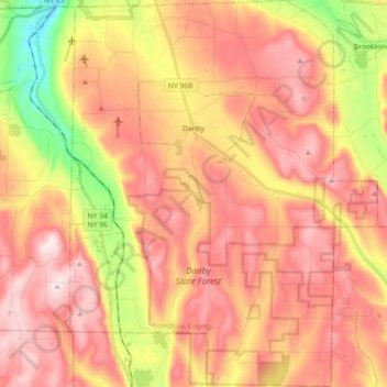
Name: Town of Danby topographic map, elevation, terrain.
Location: Town of Danby, Tompkins County, New York, United States (42.26275 -76.53851 42.39654 -76.39437)
Average elevation: 404 m
Minimum elevation: 134 m
Maximum elevation: 586 m
Other topographic maps
Click on a map to view its topography, its elevation and its terrain.
Hartung-Boothroyd Observatory
United States > New York > Tompkins County > Town of Dryden > Varna
The primary 0.6m mirror was constructed from a Pyrex 1/8-scale test pouring as part of technology development for the Palomar Observatory 200-inch telescope. The mirror was polished and mounted in a lightweight tube in the late 1930s under Boothroyd's direction, but World War II deferred its planned use in a…
Average elevation: 477 m