
Syde topographic map
Click on the map to display elevation.
About this map
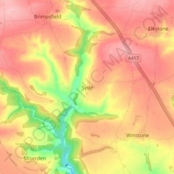
Name: Syde topographic map, elevation, terrain.
Average elevation: 238 m
Minimum elevation: 152 m
Maximum elevation: 285 m
Gloucestershire trails, hiking, mountain biking, running and outdoor activities
Other topographic maps
Click on a map to view its topography, its elevation and its terrain.
Little Rissington
United Kingdom > England > Gloucestershire > Cotswold District
Average elevation: 171 m
Bourton-on-the-Water
United Kingdom > England > Gloucestershire > Cotswold District
Average elevation: 155 m
Worcestershire (detached)
United Kingdom > England > Gloucestershire > Cotswold District
Average elevation: 103 m
Cirencester Park
United Kingdom > England > Gloucestershire > Cotswold District > Sapperton
Average elevation: 162 m
Cold Aston
United Kingdom > England > Gloucestershire > Cotswold District > Cold Aston
Average elevation: 189 m
Cirencester
United Kingdom > England > Gloucestershire > Cotswold District
On Cotswold Avenue is the site of a Roman amphitheatre which, while buried, retains its shape in the earthen topography of the small park setting. Cirencester was one of the most substantial cities of Roman-era Britain.
Average elevation: 128 m
Upper Rissington
United Kingdom > England > Gloucestershire > Cotswold District
Average elevation: 208 m
Bourton-on-the-Hill
United Kingdom > England > Gloucestershire > Cotswold District
Average elevation: 200 m
Coberley
United Kingdom > England > Gloucestershire > Cotswold District > Coberley
Average elevation: 234 m
Chipping Campden
United Kingdom > England > Gloucestershire > Cotswold District
Average elevation: 191 m
Moreton-in-Marsh
United Kingdom > England > Gloucestershire > Cotswold District
Average elevation: 135 m
Bushley Muzzard, Brimpsfield
United Kingdom > England > Gloucestershire > Cotswold District > Nettleton > Watercombe
Average elevation: 261 m
Bibury
United Kingdom > England > Gloucestershire > Cotswold District
The parish is approximately rectangular and stretches far to the rolling, elevated, north. It includes on outlying settlement, Ablington, in the upper valley. Bibury Farm is 300 metres (330 yd) from the village, 151 metres (495 ft) above Ordnance Datum (AOD), which is a similar elevation to much of the north.…
Average elevation: 135 m
Knap House Quarry, Birdlip
United Kingdom > England > Gloucestershire > Cotswold District > Birdlip
Average elevation: 222 m
Botany Bay Wood
United Kingdom > England > Gloucestershire > Cotswold District > Stow-on-the-Wold
Average elevation: 171 m
Baunton
United Kingdom > England > Gloucestershire > Cotswold District > Baunton
Average elevation: 146 m
Somerford Keynes
United Kingdom > England > Gloucestershire > Cotswold District
Average elevation: 92 m
Evenlode
United Kingdom > England > Gloucestershire > Cotswold District > Evenlode
Average elevation: 134 m
Great Rissington
United Kingdom > England > Gloucestershire > Cotswold District > Great Rissington
Average elevation: 168 m
Bagendon
United Kingdom > England > Gloucestershire > Cotswold District > Bagendon
Average elevation: 171 m
Didmarton
United Kingdom > England > Gloucestershire > Cotswold District > Didmarton
Average elevation: 147 m
Daglingworth
United Kingdom > England > Gloucestershire > Cotswold District > Daglingworth
Average elevation: 169 m
Poulton
United Kingdom > England > Gloucestershire > Cotswold District > Poulton
Average elevation: 109 m
Winson
United Kingdom > England > Gloucestershire > Cotswold District > Winson
Average elevation: 145 m
Windrush
United Kingdom > England > Gloucestershire > Cotswold District > Windrush
Average elevation: 155 m
Sherborne
United Kingdom > England > Gloucestershire > Cotswold District > Sherborne
Average elevation: 156 m
Elkstone
United Kingdom > England > Gloucestershire > Cotswold District > Elkstone
Average elevation: 234 m
Down Ampney
United Kingdom > England > Gloucestershire > Cotswold District > Down Ampney
Average elevation: 85 m
Hazleton
United Kingdom > England > Gloucestershire > Cotswold District > Hazleton
Average elevation: 227 m
Chedworth
United Kingdom > England > Gloucestershire > Cotswold District > Chedworth
Average elevation: 187 m
Naunton
United Kingdom > England > Gloucestershire > Cotswold District > Naunton
Average elevation: 201 m
Chipping Campden
United Kingdom > England > Gloucestershire > Cotswold District
Average elevation: 191 m
Temple Guiting
United Kingdom > England > Gloucestershire > Cotswold District
Average elevation: 226 m
Cirencester
United Kingdom > England > Gloucestershire > Cotswold District
On Cotswold Avenue is the site of a Roman amphitheatre which, while buried, retains its shape in the earthen topography of the small park setting. Cirencester was one of the most substantial cities of Roman-era Britain.
Average elevation: 128 m
Didmarton
United Kingdom > England > Gloucestershire > Cotswold District > Didmarton
Average elevation: 147 m
Cirencester
United Kingdom > England > Gloucestershire > Cotswold District > Chesterton
On Cotswold Avenue is the site of a Roman amphitheatre which, while buried, retains its shape in the earthen topography of the small park setting. Cirencester was one of the most substantial cities of Roman-era Britain.
Average elevation: 128 m