
Make a donation
Gear up for your next adventure:
As an Amazon Associate, this site earns from qualifying purchases at no extra cost to you.
So-Hi topographic map
Click on the map to display elevation.
Make a donation
Gear up for your next adventure:
As an Amazon Associate, this site earns from qualifying purchases at no extra cost to you.
About this map
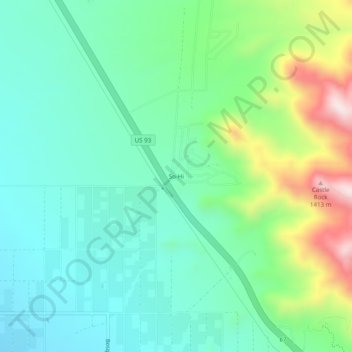
Name: So-Hi topographic map, elevation, terrain.
Location: So-Hi, Mohave County, Arizona, États-Unis d'Amérique (35.22445 -114.16701 35.26445 -114.12701)
Average elevation: 1,044 m
Minimum elevation: 903 m
Maximum elevation: 1,416 m
Make a donation
Gear up for your next adventure:
As an Amazon Associate, this site earns from qualifying purchases at no extra cost to you.
Other topographic maps
Click on a map to view its topography, its elevation and its terrain.
Kingman
États-Unis d'Amérique > Arizona > Mohave County
Traversée par la célèbre route 66, la ville de Kingman se dit le cœur de cette dernière (The Heart of historic route 66). Située à quelques kilomètres de Bullhead City et à environ deux heures de route du parc national du Grand Canyon, la vie est relativement loin de la ville urbaine de la capitale…
Average elevation: 1,131 m
Make a donation
Gear up for your next adventure:
As an Amazon Associate, this site earns from qualifying purchases at no extra cost to you.