
Bor topographic map
Interactive map
Click on the map to display elevation.
Bor
Crni Vrh is a mountain 30 km from the city center. Highest peak has an elevation of 1,043 m (3,422 ft) above sea level. It has several ski tracks anda ski lift. The main ski track is 1,100 m long and has height span of 260 m. Just 16 km from the city center there is another mountain Stol. Its highest peak has an elevation of 1,156 meters above sea level. Like nearby Veliki Krš and Mali Krš, Stol has a number of pronounced karst formations. It is also a destination for mountaineering. It has a ski lift and ski trails. Mountain Rtanj in Boljevac municipality is 50 km away from Bor.
About this map
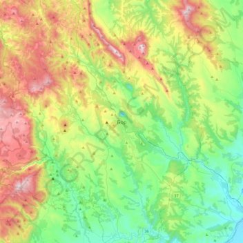
Name: Bor topographic map, elevation, terrain.
Average elevation: 474 m
Minimum elevation: 116 m
Maximum elevation: 1,147 m
Other topographic maps
Click on a map to view its topography, its elevation and its terrain.
National Park Djerdap
Serbia > Central Serbia > Bor Administrative District
The Blederija river springs from two karstic springs at an altitude of 389 m (1,276 ft), under the Topla Bara peak. The springs are 5 m (16 ft) away from each other and one has a water temperature around 8 °C (46 °F), while the other has a constant 17 °C (63 °F). The river forms several cascades in the…
Average elevation: 420 m
Negotin
Serbia > Central Serbia > Bor Administrative District > Negotin Municipality
Average elevation: 88 m
Kladovo
Serbia > Central Serbia > Bor Administrative District > Kladovo Municipality
Average elevation: 89 m
Boljetin
Serbia > Central Serbia > Bor Administrative District > Majdanpek Municipality
Average elevation: 388 m
Dusanovac
Serbia > Central Serbia > Bor Administrative District > Negotin Municipality
Average elevation: 91 m
Petrovo Selo
Serbia > Central Serbia > Bor Administrative District > Kladovo Municipality
Average elevation: 341 m