
Mpanda topographic map
Interactive map
Click on the map to display elevation.
About this map
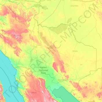
Name: Mpanda topographic map, elevation, terrain.
Location: Mpanda, Katavi, Western Zone, Tanzania (-7.74505 29.95819 -5.18255 32.74451)
Average elevation: 1,140 m
Minimum elevation: 763 m
Maximum elevation: 2,298 m
Other topographic maps
Click on a map to view its topography, its elevation and its terrain.
Gombe Stream National Park
Gombe Stream National Park, Kigoma Rural, Katavi, Western Zone, Tanzania
Average elevation: 1,001 m
Katavi National Park
Katavi National Park, Mpanda, Katavi, Western Zone, Tanzania
Average elevation: 1,124 m