
Upington topographic map
Interactive map
Click on the map to display elevation.
Upington
The elevation of Upington is 2,742 feet (835 metres). It is the closest large centre to the Augrabies Falls (arguably the greatest of South African waterfalls) and the Kgalagadi Transfrontier Park. The landscape is very arid but the soil is fertile and crops such as fruit are grown in irrigated fields. The area is best known for its export-quality grapes, raisins and wines, which are cultivated on the rich flood plains of the Orange River.
About this map
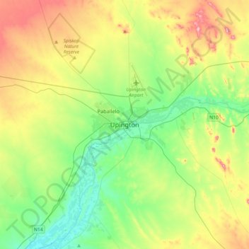
Name: Upington topographic map, elevation, terrain.
Average elevation: 849 m
Minimum elevation: 765 m
Maximum elevation: 1,006 m
Other topographic maps
Click on a map to view its topography, its elevation and its terrain.
Donkie-ieland
South Africa > Northern Cape > ZF Mgcawu District Municipality > Kai !Garib Local Municipality
Average elevation: 772 m
Rietfontein
South Africa > Northern Cape > ZF Mgcawu District Municipality > Mier Local Municipality
Average elevation: 849 m