Geolocate

Gashenyi topographic map

Interactive map

Click on the map to display elevation.

About this map

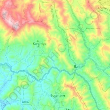
Name: Gashenyi topographic map, elevation, terrain.

Location: Gashenyi, Gakenke, Northern Province, Rwanda (-1.69898 29.82197 -1.57788 29.88022)

Average elevation: 1,934 m

Minimum elevation: 1,598 m

Maximum elevation: 2,650 m

Other topographic maps

Click on a map to view its topography, its elevation and its terrain.

Muyongwe

Rwanda > Northern Province > Gakenke

Average elevation: 1,846 m

Kivuruga

Rwanda > Northern Province > Gakenke

Average elevation: 1,932 m

Coko

Rwanda > Northern Province > Gakenke

Average elevation: 1,735 m

Gakenke

Rwanda > Northern Province > Gakenke

Average elevation: 1,806 m