
Villach topographic map
Click on the map to display elevation.
About this map
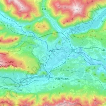
Name: Villach topographic map, elevation, terrain.
Location: Villach, Carinthia, Austria (46.55849 13.69369 46.66836 13.97923)
Average elevation: 829 m
Minimum elevation: 476 m
Maximum elevation: 1,906 m
Other topographic maps
Click on a map to view its topography, its elevation and its terrain.
Eisentratten
Austria > Carinthia > Bezirk Spittal an der Drau > Krems in Kärnten
Average elevation: 1,094 m
Pockhorn
Austria > Carinthia > Bezirk Spittal an der Drau > Heiligenblut am Großglockner
Average elevation: 1,631 m
Großglockner
Austria > Carinthia > Bezirk Spittal an der Drau > Heiligenblut am Großglockner
The Glockner is the highest mountain in the Alps east of the Ortler range, about 175 km (109 mi) away, and, after Mont Blanc, has the second greatest topographic isolation of all mountains in the Alps. Even its topographic prominence, at 2,424 m (7,953 ft), is the second highest after Mont Blanc in the entire…
Average elevation: 3,128 m
Lake Pressegg
Austria > Carinthia > Bezirk Hermagor > Hermagor-Pressegger See > Presseggersee > Paßriach
Average elevation: 627 m
Obermöschach
Austria > Carinthia > Bezirk Hermagor > Hermagor-Pressegger See > Hermagor
Average elevation: 765 m
Sankt Wolfgang
Austria > Carinthia > Bezirk Spittal an der Drau > Seeboden am Millstätter See > Seebach
Average elevation: 626 m
Freier Seezugang Millstätter See bei Spittal an der Drau, Großegg
Austria > Carinthia > Bezirk Spittal an der Drau > Spittal an der Drau
Average elevation: 677 m
Pasterze
Austria > Carinthia > Bezirk Spittal an der Drau > Heiligenblut am Großglockner
Average elevation: 2,599 m
Großglockner
Austria > Carinthia > Bezirk Spittal an der Drau > Heiligenblut am Großglockner
The Glockner is the highest mountain in the Alps east of the Ortler range, about 175 km (109 mi) away, and, after Mont Blanc, has the second greatest topographic isolation of all mountains in the Alps. Even its topographic prominence, at 2,424 m (7,953 ft), is the second highest after Mont Blanc in the entire…
Average elevation: 3,128 m
Faak am See
Austria > Carinthia > Bezirk Villach-Land > Finkenstein am Faaker See > Faak am See
Average elevation: 601 m
Hintergumitsch
Austria > Carinthia > Bezirk Wolfsberg > Frantschach-Sankt Gertraud
Average elevation: 662 m
Gartnerkofel
Austria > Carinthia > Bezirk Hermagor > Hermagor-Pressegger See
Average elevation: 1,705 m
Turracher Höhe
Austria > Carinthia > Reichenau
The highest point of the approx. two km long pass summit has an altitude of 1,795 m above sea level south of the Turracher Lake. The lake has a water level of 1,763 m above sea (Adria) level and is connected to the village. The Turracher Höhe, as a "classic" pass summit, is also part of a drainage divide…
Average elevation: 1,852 m
Untertauern
Austria > Carinthia > Bezirk Spittal an der Drau > Heiligenblut am Großglockner
Average elevation: 1,682 m
Klagenfurt Land
Austria > Carinthia > Bezirk Klagenfurt-Land > Krumpendorf am Wörthersee
Average elevation: 894 m
Heiligenblut
Austria > Carinthia > Bezirk Spittal an der Drau > Heiligenblut am Großglockner
Average elevation: 1,982 m
Wurzach
Austria > Carinthia > Bezirk Villach-Land > Bad Bleiberg > Bleiberg-Kreuth
Average elevation: 1,186 m
Tangern
Austria > Carinthia > Bezirk Spittal an der Drau > Spittal an der Drau
Average elevation: 691 m
Falkert
Austria > Carinthia > Bezirk Spittal an der Drau > Bad Kleinkirchheim
Average elevation: 2,023 m
Schiefling
Austria > Carinthia > Bezirk Wolfsberg > Bad Sankt Leonhard im Lavanttal
Average elevation: 849 m
Oberwinklern
Austria > Carinthia > Bezirk Villach-Land > Velden am Wörther See
Average elevation: 753 m
Wartkogel
Austria > Carinthia > Bezirk Wolfsberg > Bad Sankt Leonhard im Lavanttal
Average elevation: 964 m
Rothorn
Austria > Carinthia > Bezirk Spittal an der Drau > Dellach im Drautal
Average elevation: 2,299 m
Nassfeldpass / Passo di Pramollo
Austria > Carinthia > Bezirk Hermagor > Hermagor-Pressegger See > Sonnenalpe Naßfeld
Average elevation: 1,572 m
Frießnitz/Breznica
Austria > Carinthia > Bezirk Villach-Land > St. Jakob im Rosental
Average elevation: 559 m
Semering
Austria > Carinthia > Bezirk Villach-Land > Nötsch im Gailtal > Kühweg
Average elevation: 826 m
Maltatal
Austria > Carinthia > Bezirk Spittal an der Drau > Gmünd in Kärnten
Average elevation: 1,914 m