
Make a donation
Gear up for your next adventure:
As an Amazon Associate, this site earns from qualifying purchases at no extra cost to you.
Samothraki topographic map
Click on the map to display elevation.
Make a donation
Gear up for your next adventure:
As an Amazon Associate, this site earns from qualifying purchases at no extra cost to you.
Samothraki
Samothraki has a hot-summer Mediterranean climate. Winters are cool and rainy with occasional heavy snowstorms, especially at higher elevations.
Make a donation
Gear up for your next adventure:
As an Amazon Associate, this site earns from qualifying purchases at no extra cost to you.
About this map
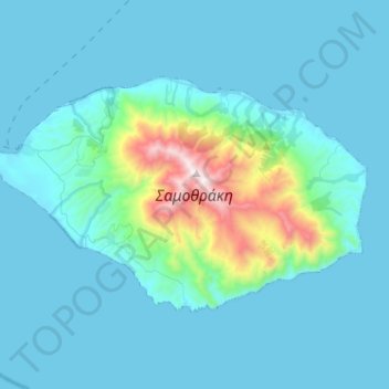
Name: Samothraki topographic map, elevation, terrain.
Average elevation: 170 m
Minimum elevation: 0 m
Maximum elevation: 1,598 m
Make a donation
Gear up for your next adventure:
As an Amazon Associate, this site earns from qualifying purchases at no extra cost to you.
Other topographic maps
Click on a map to view its topography, its elevation and its terrain.
Paliouri
Greece > Macedonia and Thrace > Evros Regional Unit > Metaxades Municipal Unit
Average elevation: 132 m
Mani
Greece > Macedonia and Thrace > Evros Regional Unit > Didymoteicho Municipal Unit
Mani (Greek: Μάνη) is a village and a community in the municipality of Didymoteicho in the Evros regional unit, Greece. It is situated near the left bank of the river Erythropotamos, 2 km west of Karoti, 4 km northeast of Kyani and 10 km northwest of Didymoteicho town centre. In 2021 its population was 364…
Average elevation: 53 m
Make a donation
Gear up for your next adventure:
As an Amazon Associate, this site earns from qualifying purchases at no extra cost to you.