

Niagara River topographic map
Click on the map to display elevation.
Niagara River
The Niagara River (/naɪˈæɡərə, -ɡrə/ ny-AGG-ər-ə, -grə) flows north from Lake Erie to Lake Ontario, forming part of the border between Ontario, Canada, to the west, and New York, United States, to the east. The river, occasionally described as a strait, is approximately 58 kilometres (36 miles) long and is known for the Niagara Falls. Over the past 12,000 years, the falls have moved roughly 11 kilometres (6.8 mi) upstream from the leading edge of the Niagara Escarpment, creating a gorge below the falls. Today, the diversion of the river for electricity generation has significantly slowed the rate of erosion. The total elevation drop along the river is 99 metres (325 ft). The Niagara downstream from the falls, includes the Niagara Whirlpool and additional rapids.
About this map
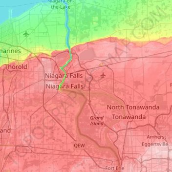
Name: Niagara River topographic map, elevation, terrain.
Location: Niagara River, Erie County, New York, United States (42.90481 -79.07625 43.26240 -78.88155)
Average elevation: 160 m
Minimum elevation: 72 m
Maximum elevation: 219 m
Other topographic maps
Click on a map to view its topography, its elevation and its terrain.

Buffalo
United States > New York > Erie County
The Buffalo metropolitan area is on the Erie/Ontario Lake Plain of the Eastern Great Lakes Lowlands, a narrow plain extending east to Utica, New York. The city is generally flat, except for elevation changes in the University Heights and Fruit Belt neighborhoods. The Southtowns are hillier, leading to the…
Average elevation: 192 m



Onondaga Escarpment
United States > New York > Erie County > Village of Akron
Average elevation: 236 m



Onondaga Escarpment
United States > New York > Erie County > Village of Akron
Average elevation: 236 m


Chestnut Ridge Park
United States > New York > Erie County > Town of Orchard Park
Average elevation: 314 m


Fisherman's Landing
United States > New York > Erie County > Town of Grand Island > Grandyle Village
Average elevation: 179 m
