

Kyffhäuser topographic map
Click on the map to display elevation.
Kyffhäuser
Der rund 12,5 km lange und 5,5 km breite Kyffhäuser erstreckt sich südlich der ca. 6 km breiten Goldene Aue genannten Niederung der Helme, die ihn vom Unterharz trennt. Südwestlich (und südlich) des Kyffhäusers liegen die Höhenzüge Windleite und Hainleite.
About this map
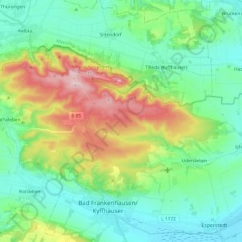
Name: Kyffhäuser topographic map, elevation, terrain.
Average elevation: 221 m
Minimum elevation: 120 m
Maximum elevation: 475 m
Other topographic maps
Click on a map to view its topography, its elevation and its terrain.
Fischertal
Deutschland > Thüringen > Kyffhäuserkreis > Bad Frankenhausen/Kyffhäuser
Average elevation: 235 m