
Madikeri topographic map
Interactive map
Click on the map to display elevation.
About this map
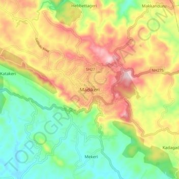
Name: Madikeri topographic map, elevation, terrain.
Average elevation: 1,054 m
Minimum elevation: 880 m
Maximum elevation: 1,283 m
Madikeri features a tropical highland climate as it has an elevation of 1,170 m (3,840 ft). Madikeri is located at 12°25′N 75°44′E / 12.42°N 75.73°E / 12.42; 75.73. Madikeri lies in the Western Ghats and is a popular hill station. The nearest cities are Hassan to the north, Mangaluru to the west, and Mysuru to the east. Kannur from Kerala is about 100 km (62 mi) away. The nearest international airport is Kannur International Airport which is 80 km (50 mi) away.
Other topographic maps
Click on a map to view its topography, its elevation and its terrain.
Kunjila
India > Karnataka > Madikeri taluku > Kunjila
Kunjila, Madikeri taluku, Kodagu, Karnataka, 571212, India
Average elevation: 914 m
Bhagamandala
India > Karnataka > Madikeri taluku
Bhagamandala, Madikeri taluku, Kodagu, Karnataka, 571247, India
Average elevation: 942 m