Caterham topographic map
Interactive map
Click on the map to display elevation.
About this map
![Caterham topographic map, elevation, terrain](/pub/maps/node/btt6/n7nsfrr/thumbnail.jpg)
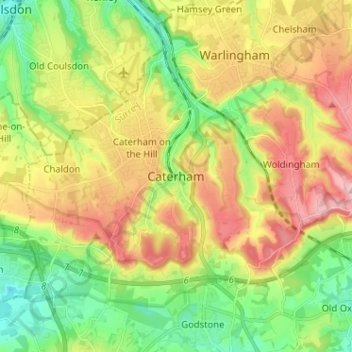
Name: Caterham topographic map, elevation, terrain.
Location: Caterham, Tandridge, Surrey, England, CR3 6XS, United Kingdom (51.24197 -0.11710 51.32197 -0.03710)
Average elevation: 157 m
Minimum elevation: 70 m
Maximum elevation: 270 m
In 1840 Caterham contained a total of 477 residents (figures taken from that census, compiled in an 1848 topographical encyclopedia) and in 1848 468 acres (189 ha) of its 2,386 acres (966 ha) were common land. Similar to today, 175 acres (71 ha) mostly steeper acres were woodland.
Other topographic maps
Click on a map to view its topography, its elevation and its terrain.
![Godstone topographic map, elevation, terrain](/pub/maps/relation/8brr/3rf4z4/icon.jpg)
Godstone
United Kingdom > England > Surrey > Tandridge
Godstone, Tandridge, Surrey, England, United Kingdom
Average elevation: 91 m
![New Chapel topographic map, elevation, terrain](/pub/maps/node/v9tj/3qp8z3q/icon.jpg)
New Chapel
United Kingdom > England > Surrey > Tandridge
New Chapel, Horne, Tandridge, Surrey, England, RH7 6NB, United Kingdom
Average elevation: 64 m
![Burstow topographic map, elevation, terrain](/pub/maps/relation/lw51/3jp214/icon.jpg)
Burstow
United Kingdom > England > Surrey > Tandridge
Burstow, Tandridge, Surrey, England, United Kingdom
Average elevation: 67 m
![Botley Hill topographic map, elevation, terrain](/pub/maps/node/kxb3/dz5t73zs/icon.jpg)
Botley Hill
United Kingdom > England > Surrey > Tandridge
Botley Hill, Tandridge, Surrey, England, CR3 7AN, United Kingdom
Average elevation: 206 m
![Bletchingley topographic map, elevation, terrain](/pub/maps/relation/zpt6/3jp2z4/icon.jpg)
Bletchingley
United Kingdom > England > Surrey > Tandridge
Bletchingley, Tandridge, Surrey, England, United Kingdom
Average elevation: 106 m
![Horne topographic map, elevation, terrain](/pub/maps/relation/2lrr/rktl3q/icon.jpg)
Horne
United Kingdom > England > Surrey > Tandridge
Horne, Tandridge, Surrey, England, United Kingdom
Average elevation: 68 m
![Dormansland topographic map, elevation, terrain](/pub/maps/relation/kqnh/623p3l/icon.jpg)
Dormansland
United Kingdom > England > Surrey > Tandridge
Dormansland, Tandridge, Surrey, England, United Kingdom
Average elevation: 78 m
![Tatsfield topographic map, elevation, terrain](/pub/maps/relation/b1zs/mbncgp/icon.jpg)
Tatsfield
United Kingdom > England > Surrey > Tandridge
Tatsfield, Tandridge, Surrey, England, United Kingdom
Average elevation: 176 m
![Woldingham topographic map, elevation, terrain](/pub/maps/relation/744s/7tvxtf/icon.jpg)
Woldingham
United Kingdom > England > Surrey > Tandridge
Woldingham, Tandridge, Surrey, England, United Kingdom
Average elevation: 183 m
![Oxted topographic map, elevation, terrain](/pub/maps/relation/x8s8/l2xbs8/icon.jpg)
Oxted
United Kingdom > England > Surrey > Tandridge
Oxted, Tandridge, Surrey, England, United Kingdom
Average elevation: 128 m
![Whyteleafe topographic map, elevation, terrain](/pub/maps/relation/9z14/85tr1h/icon.jpg)
Whyteleafe
United Kingdom > England > Surrey > Tandridge
Whyteleafe, Tandridge, Surrey, England, United Kingdom
Average elevation: 153 m
![Warlingham topographic map, elevation, terrain](/pub/maps/relation/7jgp/4gvzgt/icon.jpg)
Warlingham
United Kingdom > England > Surrey > Tandridge
Warlingham, Tandridge, Surrey, England, United Kingdom
Average elevation: 163 m
![Chaldon topographic map, elevation, terrain](/pub/maps/relation/jntf/lz4v18/icon.jpg)
Chaldon
United Kingdom > England > Surrey > Tandridge
Chaldon, Tandridge, Surrey, England, United Kingdom
Average elevation: 181 m
![Nutfield topographic map, elevation, terrain](/pub/maps/relation/kq1h/dr8t4s/icon.jpg)
Nutfield
United Kingdom > England > Surrey > Tandridge
Nutfield, Tandridge, Surrey, England, United Kingdom
Average elevation: 88 m
![Crowhurst topographic map, elevation, terrain](/pub/maps/relation/pwmt/mq91tp/icon.jpg)
Crowhurst
United Kingdom > England > Surrey > Tandridge
Crowhurst, Tandridge, Surrey, England, United Kingdom
Average elevation: 62 m
![Titsey topographic map, elevation, terrain](/pub/maps/relation/65gt/9nfmt6/icon.jpg)
Titsey
United Kingdom > England > Surrey > Tandridge
Titsey, Tandridge, Surrey, England, United Kingdom
Average elevation: 185 m
![Limpsfield topographic map, elevation, terrain](/pub/maps/relation/m6cz/lz41s8/icon.jpg)
Limpsfield
United Kingdom > England > Surrey > Tandridge
Limpsfield, Tandridge, Surrey, England, United Kingdom
Average elevation: 110 m