
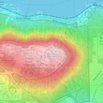
Burnaby Mountain topographic map
Interactive map
Click on the map to display elevation.
About this map
Name: Burnaby Mountain topographic map, elevation, terrain.
Average elevation: 167 m
Minimum elevation: 0 m
Maximum elevation: 373 m
Due to its relatively high elevation, snow will often fall on the higher levels of Burnaby Mountain while rain falls in the surrounding cities. Tobogganing is a popular pastime at Centennial Park on winter days with snow.
Other topographic maps
Click on a map to view its topography, its elevation and its terrain.
Burnaby
Canada > British Columbia > Metro Vancouver Regional District > Burnaby
Burnaby, District of North Vancouver, Metro Vancouver Regional District, British Columbia, V5G 1M2, Canada
Average elevation: 144 m
Riverway Sports Complex
Canada > British Columbia > Metro Vancouver Regional District > Burnaby
Riverway Sports Complex, 8605, Burnaby, Metro Vancouver Regional District, British Columbia, Canada
Average elevation: 42 m
Stride Hill
Canada > British Columbia > Metro Vancouver Regional District > Burnaby
Stride Hill, Burnaby, Metro Vancouver Regional District, British Columbia, Canada
Average elevation: 68 m
Burnaby Lake
Canada > British Columbia > Metro Vancouver Regional District > Burnaby
Burnaby Lake, Burnaby, Metro Vancouver Regional District, British Columbia, Canada
Average elevation: 32 m
Central Park
Canada > British Columbia > Metro Vancouver Regional District > Burnaby
Central Park, Metrotown, Burnaby, Metro Vancouver Regional District, British Columbia, Canada
Average elevation: 113 m
Brentwood
Canada > British Columbia > Metro Vancouver Regional District > Burnaby
Brentwood, Burnaby, Metro Vancouver Regional District, British Columbia, Canada
Average elevation: 69 m
Barnet Marine Park
Canada > British Columbia > Metro Vancouver Regional District > Burnaby
Barnet Marine Park, Barnet, Burnaby, Metro Vancouver Regional District, British Columbia, Canada
Average elevation: 95 m